Elk Island National Park (Elk Island) is a beautiful, wildlife-packed park located in central Alberta. The park is the only fully fenced national park in Canada and is best known for its ungulate inhabitants including elk, moose, plains bison, wood bison, white-tailed deer, and mule deer (Figure 1). The northern and southern portions of the park are divided by highway 16, separating the park into Elk Island-north and Elk Island-south. The fenced perimeter of each site keeps ungulates contained, which separates the two subspecies of bison and prevents them from interacting with cattle outside of the park. A separation from cattle is necessary for Elk Island’s bison to remain disease-free so Elk Island can continue to support bison reintroduction efforts around the world¹.
  |
  |
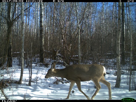 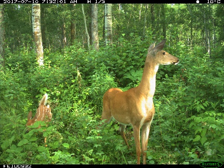 |
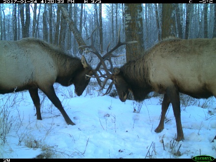
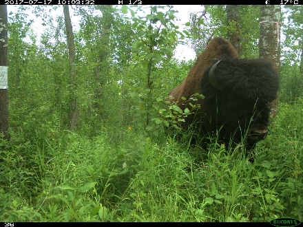
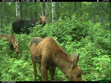
Figure 1. Ungulates (hoofed mammals) of Elk Island National Park. Top row (left to right): two elk sparring, moose cow and twins, mule deer. Bottom row (left to right): wood bison in Elk Island-south, plains bison in Elk Island-north, white-tailed deer doe and fawn.
While the fenced perimeter is effective at containing the ungulates, it does create some management issues. For example, ungulate densities tend to be very high in Elk Island as the fence prevents dispersal and limits large predators, two factors that can naturally regulate population densities. Park staff actively manage ungulates (i.e. cull or translocate) to prevent densities from becoming too high, which would damage the ecological integrity of the park¹. Therefore, managers need accurate density estimates for each ungulate species to inform their management plans. To measure ungulate density, aerial surveys are conducted in Elk Island annually. Park managers are confident in the aerial counts of bison, elk, and moose because of the high visibility of these species. However, the survey has limitations including low sightability of deer and limited demographic data (i.e. age class, sex) for all species.
To address these limitations, we are evaluating camera traps as an alternative to aerial surveys. If density estimates from camera traps are similar to estimates produced from the aerial surveys, camera traps may be considered for ongoing monitoring since they can provide more detailed population information. Potential benefits of camera traps include more information on deer populations, robust demographic information for all ungulates, and continuous data throughout the year. Cameras can monitor ungulate populations year-round, while annual aerial surveys provide a once-per-year snapshot each winter.
Several methods have been developed to use camera traps for estimating densities of species without individually identifiable markings²⁻⁴, but these methods still need to be tested. Elk Island is an ideal location to test density methods for camera traps since the aerial surveys provide “known” population sizes for elk, bison, and moose. With this information, we can assess the accuracy of our camera trap estimates. We will estimate density using the Random Encounter and Staying Time (REST) method⁴, which uses the time spent in front of the camera and sampling effort (area and time surveyed) to calculate density. We hope to answer the following questions:
- Does the REST method provide density estimates that are comparable to the aerial survey for elk, bison, and moose? (we will assess both accuracy and precision)
- Does the REST method perform differently for herding vs solitary species?
Progress
We expanded our study areas to include 3 sites (Figure 2): Elk Island-north, Elk Island-south, and Cooking Lake – Blackfoot Provincial Recreation Area (Blackfoot PRA). At all three sites, cameras were deployed in a 2x2 km grid. Camera deployment occurred in Elk Island-north (n=31) and Elk Island-south (n=12) in January 2017, and occurred in Blackfoot PRA (n=23) in April 2019. We expanded the aerial survey to include Blackfoot PRA, so we have aerial survey counts corresponding with each camera survey.
We are currently finishing our final field season and processing the hundreds of thousands of camera trap photos. Photos are processed by adding tags for species, sex, age class, and number of animals. Once the photos are processed, we will apply the REST method and compare our estimates with the corresponding aerial surveys.
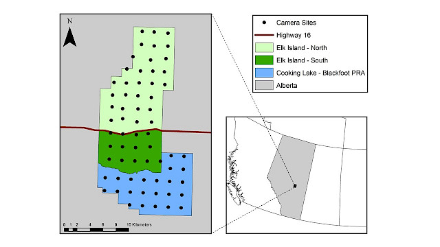
Figure 2. Our three field sites are Elk Island-north (134 km²), Elk Island-south (60 km²), and Blackfoot PRA (97 km²). Elk Island National Park is divided by Highway 16. Blackfoot PRA shares a border with Elk Island-south.
Significance and Next Steps:
If the REST method produces comparable densities to the aerial surveys, we will apply the method to estimate white-tailed deer and mule deer densities. We will also determine the density of subgroups and use them to calculate commonly used demographic ratios (i.e. female:male, cow:calf). Our study will help inform Elk Island management plans and will also contribute more broadly to the assessment of camera trap methods. Since we have known population densities, we will determine if there is support to apply the REST method in areas where assessing accuracy is not possible due to lack of census data.
Once we have our density estimates for each site, year, and species, we will begin the second phase of the project. Phase 2 entails using the relative densities we estimate in phase 1 to examine how ungulates change their spatial patterns after bison numbers are reduced by culling/translocations.
 |
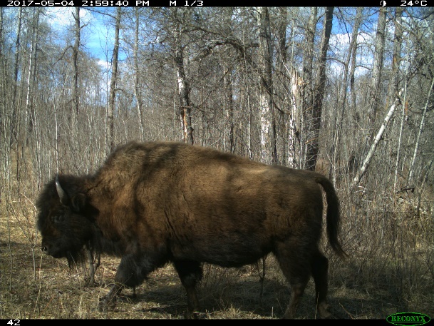 |
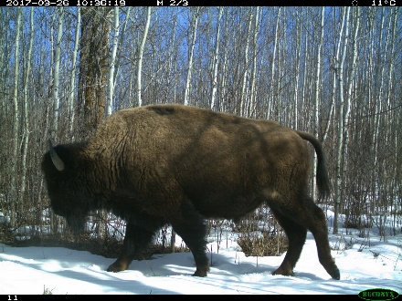
Figure 3. Plains bison (left) reside in Elk Island-north and wood bison (right) reside in Elk Island-south. Park staff actively manage bison populations through culling/translocations, alternating between the subspecies each year. This protects the ecological integrity of the park by preventing overgrazing, and also supports bison reintroduction efforts around the world.
About the Author:
Jenny Foca is an MSc student in the Boyce lab at the University of Alberta. Her research interests include camera trap applications, spatial ecology, and examining the effects of management actions on community dynamics.
Project Partners:
University of Alberta, The Friends of Elk Island Society, Parks Canada, Kings University, Alberta Biodiversity Monitoring Institute, Safari Club International – Northern Alberta Chapter, Alberta Fish and Game Association, Innotech Alberta, Alberta Conservation Association.
References:
- Parks Canada. What We Heard: Ungulate Management in Elk Island National Park - October 2016 to June 2017. (2017).
- Rowcliffe, J. M., Field, J., Turvey, S. T. & Carbone, C. Estimating animal density using camera traps without the need for individual recognition. J. Appl. Ecol. 45, 1228–1236 (2008).
- Chandler, R. B. & Royle, J. A. Spatially explicit models for inference about density in unmarked or partially marked populations. Ann. Appl. Stat. 7, 936–954 (2013).
- Nakashima, Y., Fukasawa, K. & Samejima, H. Estimating animal density without individual recognition using information derivable exclusively from camera traps. J. Appl. Ecol. 55, 735–744 (2018).