Lisa Humphries
Lisa is a wildlife enthusiast who lives on a stretch of forest that hugs the sea and climbs directly to the sky. The Sea to Sky Area...the Sunshine Coast backs onto Squamish hosting an array of species which inhabit every level of elevation.
https://www.youtube.com/@sunshinecoasttrailcam
All Videos Have Tag "Irgens Creek"
Current Survey Footage!
https://youtube/rERfM4cEdWs
https://youtube/XYUC9YT4wQQ
https://youtube/_5VAhLUGFlQ
https://youtube/FVW7BfZFjUA
https://youtube/wSmEYrLpbWc
https://youtube/voGHyHGyCZg
Visit my online sales for outdoor tech and adventure wear
https://www.northernexpress.guru
And most of all, help us protect the magical wildlife areas if the Sunshine Coast by Checking out and Purchasing prints of the infamous carver Brian Bosse, here in Sechelt, B.C
Available soon at WWW.NORTHERNEXPRESS.GURU
See Complete Project Outline below
The purpose of the Irgens Creek Project is to better understand the direct impact of industry activities on mammals and birds, black bear den characteristics and use development, together with how forest harvesting and roading, affect mammal communities in this highly developed area between Chapman Creek and Burnett Falls. Similarly, we aim to depict the trove of species that live in or frequent this area, between the elevation of 200 meters to 400 meters above sea level.
Irgens Creek is the first substantial valley providing shelter from the weather patterns hitting the Coast. On a cold and stormy day, it is peaceful in Irgens Creek. In the full heat of the summer, when clear cuts are reaching 110 degress or higher, Irgens Creek is a cool and refreshing spot for the animals that live at the various elevations which this small but productive creek spans.
Located next to a municIpal road which becomes Forest Service Road as it leads you past the landfill, the walking trails of Chapman Creek and towards the Gravity Park and The Tetrahedron.
Irgens Creek leads you through steep terrain at the 200 meter level to a swampy area at about 300 meters, between Dusty Rd and Burnett Falls. This is a very productive area for multiple species which proliferate in this basin, some seasonally. A true watershed, the basin which becomes Irgens Creek collecting water which runs beneath the surface of the forest floor, the rocks and cliffs, to create Irgens Creek and the seasonal swamp lands on this shoulder of the mountain as it rises quickly from Porpoise Bay Inlet to Mt Steele.
Species Census and Citizen Science
Most Canadians do not realise that species data relies for a large part, on reported sightings and data from trap lines. BC Parks and lands supports many citizen science projects. This survey is being conducted within the boundaries of the 30 meter easement of the stream.
https://ibis.geog.ubc.ca/biodiversity/CitizenScienceProjects.html
https://science.gc.ca/site/science/en/citizen-science-portal#wb-auto-4
https://www.env.gov.bc.ca/fia/documents/fieldguide_speciesatrisk_coast.pdf
Threatend Species Sightings
I will be playing the call of the Northern Goshawk in an attempt to sight a nest. The Species map indicates that this area is perfect for the Northern Goshawk.
https://www2.gov.bc.ca/assets/gov/farming-natural-resources-and-industry/forestry/bc-timber-sales/ems-sfm-certification/business-area/strait-of-georgia/tsg_goshawk-protocol-loughborough.pdf
https://www2.gov.bc.ca/gov/content/environment/plants-animals-ecosystems/species-ecosystems-at-risk/implementation/conservation-projects-partnerships/northern-goshawk#:~:text=Like%20other%20birds%2C%20both%20subspecies,federal%20Species%20at%20Risk%20Act.
Transient Species Sightings
Canada Lynx have historically been spotted on the Sunshine Coast.
LYNX
Population density usually is less than 10 (locally up to 20) per 100 sq km, depending on prey availability. Mean densities range between 2 and 9 per 100 sq km (McCord and Cardoza 1982).Based on radio telemetry Lynx have a given area between 8 and 783 km2 (3.1 and 302.3 sq mi).[7] That means if there is a food source, such as Hare up Mount Steele, Lynx will be there.
Irgens Creek Survey Camera Strategy
The principle that lake beds and streams are crown property continues in current legislation. Canadas Crown Lands Act reserves the bed of a body of water and a strip of land 30 metres from the highwater mark for the crown.
https://www2.gov.bc.ca/assets/gov/environment/air-land-water/water/working-around-water/wsa-cias-users_guide.pdf
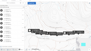
Camera Positions A,B and C.
Reffering to the diagram, you will notice that camera position:
A. is 10 inside the tree line from the municipal rd.
B. is 200 feet between the road and the stream boundry
C. is from the stream to the 30 meter boundry on the far side of the stream, relative to the road.
The purpose of camera position A is to show that animal traffic of a variety of species from the Irgens Creek Basin to Chapman Creek. That the same animals are often right inside the tree line, enjoying this multiuse area, as they travel to Chapman Creek or the landfill or to hunt urban areas.
Camera Positions B and C are posItioned to show animal pathways well utilized at different elevations.
This area has been used tradiTIonaly and contemporarily for harvesting by the Shishalh Nation. There are many Culturally Modified Trees in the area.
The shíshálh Nation asserts aboriginal title to and aboriginal rights throughout its territory. We have in the past and continue to engage in cultural activities throughout the territory, activities giving rise to aboriginal rights. We will engage in cultural activities in the territory now and into the future. In addition, we exclusively occupied our territory in and prior to 1846, and assert aboriginal title to all of our territory. Aboriginal title carries with it the right to choose the use to which the land is put. This Land Use Plan is an exercise of governance by the shíshálh Nation over our territory and is intended to provide direction on current and intended future land use and stewardship of the territory. Nothing in this Land Use Plan is intended to abrogate or derogate from shíshálh Nation aboriginal rights, including aboriginal title, and the content of this Land Use Plan is without prejudice to negotiations with the Crown.
https://shishalh.com/wp-content/uploads/2018/10/SLUP.pdf
https://journals.uvic.ca/index.php/midden/article/view/16134/6863
https://www.academia.edu/9865630/Settlement_and_Shell_Bearing_Site_Diversity_in_the_Sechelt_Inlet_System_British_Columbia
The Real Jurrasic Park
"From Mount Elphinstone in the south western most Coast Mountains of British Columbia, indicates that there the age of this hitherto undated unit is early Middle Jurassic. These rocks grade along strike to the north-northwest into a more sedimentary facies, which north of Jervis Inlet contains a probable Sinemurian (Lower Jurassic) ammonite. The Bowen Island Group thus appears to include Lower and Middle Jurassic rocks and to be coeval in part with volcanic rocks of the Bonanza Formation on Vancouver Island to the west and the Harrison Lake Formation within the central Coast Mountains 75 km to the east.
The regional geological setting of the Lower Sunshine Coast is dominated by quartz diorite and granodiorite plutonic complex, an intrusive crystalline bedrock formed during the Late Jurassic to Early Cretaceous that is very resistant to erosion and weathering (Friedman et al., 1990). However, a metavolcanic formation from the Bowen Island ! ...
... Middle Jurassic based on U-Pb dating conducted by Friedman et al. (1990) on the North summit of Mount Elphinstone, only 600 m north of the catchment area. These authors describe the lithology of the area as being "strongly foliated fine-grained amphibolites interlayered with green chlorite schist and local exposures of pale grey, white and green fine-grained schistose felsic metavolcanic rocks"
https://www.cim.org/past-award-winners/richard-friedman/
https://www.researchgate.net/publication/237173973_Age_of_the_Bowen_Island_Group_southwestern_Coast_Mountains_British_Columbia
Abstract
A new U–Pb date of for foliated felsic metavolcanic rocks of the Bowen Island Group, from Mount Elphinstone in the south-western most Coast Mountains of British Columbia, indicates that there the age of this hitherto undated unit is early Middle Jurassic. These rocks grade along strike to the north-northwest into a more sedimentary facies, which north of Jervis Inlet contains a probable Sinemurian (Lower Jurassic) ammonite. The Bowen Island Group thus appears to include Lower and Middle Jurassic rocks and to be coeval in part with volcanic rocks of the Bonanza Formation on Vancouver Island to the west and the Harrison Lake Formation within the central Coast Mountains 75 km to the east.
The regional geological setting of the Lower Sunshine Coast is dominated by quartz diorite and granodiorite plutonic complex, an intrusive crystalline bedrock formed during the Late Jurassic to Early Cretaceous that is very resistant to erosion and weathering (Friedman et al., 1990). However, a metavolcanic formation from the Bowen Island ! ...
... Middle Jurassic based on U-Pb dating conducted by Friedman et al. (1990) on the North summit of Mount Elphinstone, only 600 m north of the catchment area. These authors describe the lithology of the area as being "strongly foliated fine-grained amphibolites interlayered with green chlorite schist and local exposures of pale grey, white and green fine-grained schistose felsic metavolcanic rocks" (Friedman et al., 1990). ...
... Middle Jurassic based on U-Pb dating conducted by Friedman et al. (1990) on the North summit of Mount Elphinstone, only 600 m north of the catchment area. These authors describe the lithology of the area as being "strongly foliated fine-grained amphibolites interlayered with green chlorite schist and local exposures of pale grey, white and green fine-grained schistose felsic metavolcanic rocks" (Friedman et al., 1990). Excavated soil pits and visual inspection of bedrock blasts along the side of the forest roads show evidence of fractures ranging in size from micro to mesoscale features. ...
A shifting hydrological regime: A field investigation of snowmelt runoff processes a
The Sechelt Landfill
Dutifully collecting the waste of the Sechelt Peninsula and eternally fending off wildlife in the area, has been the status quo for the Sechelt Landfill, but this begs an exit strategy. Curiosities about the impact of the landfill on water quality and potential need for site remediation loom silently in the corner like Pandoras Box. How do we clean up the mess and transform our plastics problem globally?
Different types of incinerators are used in Canada such as Waste-to-Energy (WTE) facilities, municipal wastewater sludge incinerators, hazardous waste incinerators and biomedical incinerators. Incineration can reduce the volume of MSW by 90%.Mar 10, 2021. The inclusion of a waste plastic to fuel oil would create and additional 4 positions. The required space is 48 by 20 meters.
The seem to have alot of space at the gravel pit next door. Since this is actually a sustainable industry, it may be time to at least educate ourselves about the options available in 2023.
https://www.canada.ca/en/environment-climate-change/services/managing-reducing-waste/municipal-solid/environment.html
https://macdonaldlaurier.ca/best-solution-plastic-waste-incineration-randall-denley-inside-policy/
"The Ocean Plastics Charter the federal government signed last year allows for waste-to-energy incineration as a way to dispose of residual plastic waste. Ontario has also mentioned it as an acceptable option in its plan to make corporations responsible for plastic waste disposal.
Incineration is not a magic solution. A move to incineration would need to take into account the fact that incinerators are expensive to build and operate, requiring a substantial and steady flow of waste material to burn.
(only 3 million)
There is also the perceived problem of releasing toxins into the air, but that can be controlled by modern technology. A report by the National Research Council in the US concludes, “With current technology, waste incinerators can be designed and operated to produce nearly complete combustion of the combustible portion of waste and to emit low amounts of the pollutants of concern under normal operating conditions.”
https://www.pyrolysistooil.net/pc/All-Products/all_products?hl=en&gclid=EAIaIQobChMI9fDV6Luv_gIVkwfnCh3PQAPsEAAYAyADEgKdZ_D_BwE
https://www.pyrolysistooil.net/?hl=en&gclid=EAIaIQobChMI9fDV6Luv_gIVkwfnCh3PQAPsEAAYAyADEgKdZ_D_BwE
Feeding Raw Materials-All kinds of waste plastics, such as PP/PE/PS, single or mixed plastics
End Products-Pyro oil, solid fuel
Processing Capacity-Can be customized according to the processing capacity
Showroom Location:Turkey, United Kingdom, United States, Germany, Indo
Affiliations:
Species Studied: Bobcat; Black Bear; Canada Lynx; Cougar; Grey Wolf; Grizzly Bear; Coastal Black-Tailed Deer
Projects
-
Irgens Creek Species Census
The purpose of the Irgens Creek Project is to better understand the direct impact of industry activities on mammals and birds, black bear den characteristics and use development, together with how forest harvesting and road building,...